Mumbai
Quick links

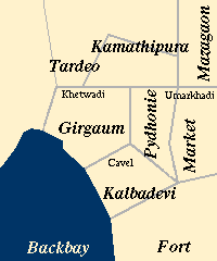
The congested inner city, just north of the old Fort walls is one of the oldest parts of Bombay. Even now, different parts are identified by the communities who live there. The names of places, and the architecture of the various localities reveal the successive migrations to Bombay.
For example, the Parsis mainly settled in Chandanwadi, near the Hormusji Wadia fire temple, the Dady Sett Agiary and Albless Baug. The Catholics lived in Cavel and Khotachi Wadi in Girgaum. Marathi brahmins and Prabhus preferred to settle on Girgaum Road, near the Portuguese church of St. Theresa's. The Muslim landlords of Khetwadi lived in the eastern parts of the inner city, in Market and Dongri.
Kamathipura, now synonymous with the phrase `red-light district', was originally named after the Kamathi workers from Andhra who came to the city from 1795, and settled in the flat areas which were rendered livable by the construction of the Hornby Vellard. The Konkanis, Kathiwadis, Kutchis and other Gujarati people, fleeing from the droughts of the 17th and 18th centuries, settled in Thakurdwar and Pydhonie.
|
If your browser does not support client-side image maps, then instead of using the map at the left, you could use the text index here: Dhobi-Talao || Market || Pydhonie || Kamathipura || Girgaum || Mazagaon || Tardeo || Fort || Malabar Hill |